ESS-render-3
Pre Application Consultation

Stenson Lane ESS

0,0
homes powered (approx)
0 hours
power per home
0MW
capacity
0.0
hectares of land

Introduction

Welcome to the Stenson Lane Energy Storage System (ESS) project website. Innova are proposing a 400 Megawatt (MW) ESS on land East of Stenson Lane, near Stenson.  

The development site covers approximately 23 acres, and is located on land to the east of Stenson Lane, near Stenson. 

The proposal would support the UKs transition to Net Zero and increased use of renewable energy through supporting the availability of energy to the National Grid. Renewable energy is characterised by its intermittent generation profile. For example, solar energy is produced during daylight hours, and wind generation fluctuates between seasons and during periods of high and low wind resource.  

Energy storage systems like the one proposed at Stenson Lane provide a solution to this, by storing electricity from the grid at times of oversupply and releasing electricity back into the grid at times of peak demand.  

The site has been carefully selected and the design has been informed by a detailed assessment process, which considers heritage, landscape, ecological and environmental designations, access, flooding, transport, and agricultural land quality. We have engaged a team of expert consultants to provide advice on the project. 

An important part of the development process is to engage with the local community. We hosted a consultation event on Monday 13th November at Stenson Fields Community Centre, Merevale Way, Stenson Fields, Derby, DE24 3EL. 

Why do we want to develop here?

The UK has committed to becoming Net Zero by 2050 and a target to decarbonise the electricity grid by 2030. Stenson Lane Energy Storage System would support the UK’s transition to Net Zero and increase the use of renewable energy through supporting the availability of energy to the National Grid.

overlay

Timeline

01

Completed

Community Consultation Event

Information regarding our Community Consultation Event will be shared here in due course.

02

Completed

Revise Proposal

Information regarding Revised Proposals will be shared here in due course.

03

Completed

Application Submitted

Information regarding the submission of our planning application will be shared here in due course.

The Location

Innova are proposing for the site to be located east of Stenson Lane, near Stenson.


Site Design


The site has been carefully selected and the design is being informed by an ongoing detailed assessment process.  

A Site Selection Assessment was initially completed which sought to identify the optimum site to accommodate the proposed development within a reasonable proximity of the Willington National Grid substation. This assessment concluded that there are two suitable locations, with the site at Stenson Lane being the most preferable.  

The proposal comprises energy storage units which will be distributed across the site in pairs, each with an associated transformer and inverter. Groups of ESS units will then be connected into a 33/132kV transformer which then feed electricity to the on-site 400kV substation, for export into the National Grid. The proposal will be connected to the nearby Willington National Grid substation via an underground cable. 

Existing mature trees and hedgerows surround the site which will be retained to provide screening. Landscape enhancements will also be delivered to further screen the development and provide an opportunity to deliver significant Biodiversity Net Gain on site. 

It is proposed that access will be from the south on Stenson Lane, with all vehicles arriving from the A5132 and A50. Internal access tracks will be created within the development site around the ESS containers and to the substation. 

If approved, the development would have an operational period of 50 years, needing only occasional maintenance. At the end of this period the development would be decommissioned, all equipment removed, and the land restored to its current use


Site Access


Construction Phase route 

It is proposed that construction vehicles will exit the Derby Southern Bypass at Junction 3 and travel west on the A514 Swarkestone Road, continuing along the A5132 before turning north onto Stenson Lane to the site.  

The number of construction vehicle trips required over the approximate 24 month construction phase has been forecast in the Construction Traffic Management Plan (CTMP) and included in the planning application. Mitigation measures to reduce the effect of construction traffic on the local highway network will be approved by the Council and adhered to by the appointed contractor.

A plan of the proposed construction traffic route is provided below:

Stenson Construction Route Plan

Operational Phase

Once operational, the site will be visited for occasional routine maintenance, typically once or twice a month by a light good vehicle. In the first five operational years, regular visits will be made by landscape contractors and ecologists to monitor and manage completed landscape works.


Specialist Environmental Surveys

We have instructed a range of specialist consultants who are currently undertaking surveys to inform the design and planning application. 

Landscape & Visual 

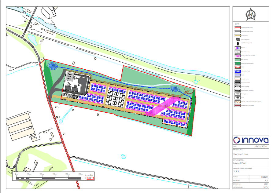
The site benefits from existing mature trees and hedgerows that provide screening and is set away from sensitive receptors. A full Landscape and Visual Impact Assessment (LVIA) has been included in the planning application. Key viewpoints from the surrounding area were assessed in the LVIA and mitigation measures proposed, including new planting, to reduce the visual impact.  

Agricultural Land Quality   

An agricultural land classification survey has been completed which confirms that the site comprises 37% Grade 3a and 63% Grade 3b land. Most of the development site is therefore not Best and Most Versatile land (Grade 3a and higher).

Archaeology and Heritage 

A Historic Environmental Desk-Based Assessment has been completed, which confirmed that no designated archaeology will be impacted by the proposed development. A geophysical survey was subsequently undertaken at the site to confirm if any previously unrecorded archaeology assets are present and the results shared with the Council’s archaeology officer. There was no evidence of archaeology being present that would require intrusive surveys at this stage.

There are three Listed Buildings, the Trent and Mersey Canal and Twyford Conservation areas in the vicinity of the site. The assessment concluded that the significance of these assets will not be impacted by the proposed development.

Ecology   

An initial Extended Phase 1 Ecology Habitat survey was completed at the site followed by badger, great crested newt, otter, water vole, breeding and wintering bir    d surveys.  These surveys have influenced the site design and are detailed in the Ecology Impact Assessment.

A Biodiversity Net Gain (BNG) assessment completed for the proposals demonstrates that the site will deliver a BNG gain in excess of the 10% required by the Environment Act 2021

Habitats of high biodiversity value, including species-rich grassland, will be introduced to deliver the biodiversity net gain. This will be managed in accordance with the Landscape and Ecology Management Plan for the first 10 years of the development, to ensure habitats become established.

Hydrology   

The site is in Flood Zone 1, meaning it has a low probability of flooding from rivers and the sea. The application was supported by a Flood Risk Assessment and Sustainable Drainage System strategy to ensure the development does not increase flood risk on or off the site. The drainage strategy relies on an attenuation-based approach to capture run-off and release it at a controlled rate.

Noise  

The planning application is supported by a Full Noise Impact Assessment which has identified the closest noise receptors and considers the potential noise generation from the proposed development, in the context of existing sound levels in the area. Several noise mitigation measures have been included in the design.